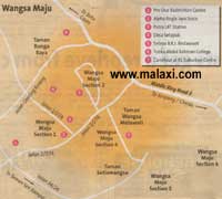
Malaxi.com Wangsa Maju Location Map  

Kuala Lumpur | Selangor | Johor | Kedah | Kelantan | Pahang | Perak | Terengganu | Negeri Sembilan | Perlis | Melaka | Pulau Pinang | Putrajaya | Sabah | Sarawak | Labuan

Home > Selangor map > Wangsa Maju map

WANGSA MAJU
By DAVID KOH AND JOE CHOO

BACK in the early days, Wangsa Maju was part of the Setapak rubber estates, north of Kuala Lumpur. It was considered too far out in the boondocks and thus, the developer probably did not target the high-end market. This provided affordable housing for a number of people in the area: students and staff of Tunku Abdul Rahman College (TARC) and Wardieburn Camp.

Today, with new developments, Wangsa Maju has become one of the largest suburbs in Kuala Lumpur
with a fair mix of high-value proper ties.

Wangsa Maju is also noted for the Alpha Angle, a shopping mall built amidst low-cost flats, with Jusco as
its anchor tenant. This could be considered unusual as the demographics are not ideal for its business. Not so with Alpha Angle and Jusco, which continue to do brisk business even after Giant and Carrefour set up shop nearby. Perhaps it is the reassuring presence of the Wangsa Maju Police Station directly in front of the mall that kept unwanted elements at bay. Or perhaps there is an environologic reason.

Within Wangsa Maju there is a hill on the eastern border with Taman Wangsa Melawati. Relative to the
Alpha Angle, it is on the north-east. The entrance of the mall -- and Jusco -- faces west -- away from
the hill. Therefore, it is shielded from the earth energy that streams down the hill. (For Google map reference, please log on to http://maps.google. co.uk/and search for "Kuala Lumpur".)

It also faces the Bunus River located to the west. This is a conducive direction for the mall and the effects are apparent. Jusco is still doing very well here.

LRT AND THE ALPHA ANCLE
The Light Rapid Transit runs through this area and services residents of Taman Sri Rampai and Wangsa Maju via the Wangsa Maju station located near Alpha Angle.

The LRT line could be a concern as fast-moving trains generate strong winds which can disperse the
earth energy collected in the area. However, trains always slow down when they approach a station, just
as when they approach the Sri Rampai station, even though it is still unused.

Thereafter, the trains come to a stop at the Wangsa Maju station. In such a situation, the movement is
slow and this may mitigate the winddispersal impact on the surrounding areas. Furthermore, since the line and station are on a hill slope, they could also be acting as a buffer to moderate the effects of onrushing energy from the hill.

Environologic factors do not change with this opening of the station: it would be interesting to observe the impact of being "embedded" in the hillside, on the station's performance. Earth energy flows rapidly downhill. The train line may disperse and deflect some of this flow, which slows down the energy movement and may create a pool of energy.

UPHILL TASK
If the entrance to the station faces uphill, that would not be helpful as it is still bombarded by oncoming
energy. Facing away from the line -- and the slow pool of energy -- is also not a conducive orientation.
Will this affect the success of the LRT system? Probably not. Will this affect the performance of the sta-
tion, in terms of utility, maintenance and sustainability?. Probably yes.

With the exception of a few houses, homes on Section 27B are arrayed in a grid that either face
uphill or downhill. Those that have an easterly facing direction are likely to do well since their backs are higher than the front.

The Wardieburn army camp is located across Jalan Genting Klang. This is an old base, existing since
the colonial days. Military personnel who live on the premises should try to ensure that their main entrance faces the river and their quarters have their backs to high land.

COLLEGE
TARC was started in 1969 with 764 enrolled in its School of Pre University Studies. Classes were initially held in Cheras and Jalan Kuantan. As the college expanded, new centres were set up in secondary schools. It moved to its present - and permanent - Main Campus in Jalan Genting Kelang in 1976.

The college was named after Malaysia's first prime minister, Tunku Abdul Rahman Putra aI-Haj, and was founded by the Malaysian Chinese Association (MCA). The college is funded by government subsidies and governed by a board of trustees. The majority of students here are ethnic Chinese due to its
association with the MCA, but there are no admission quotas and a significant proportion of non-Chinese
students study here as well.

UNIVERSITY
Contrary to popular belief, the college and Universiti Tunku Abdul Rahman (UTAR) are not connected,
The college has not been upgraded to university status either, The success of TARC prompted the Minister of Education to invite the MCA to establish UTAR in 2001.

TARC is best known for its School of Business Studies and its diploma level accounting course. It is said
that over 75% of Malaysia's accountants graduated from this school! It is also noted for producing
top ACCA scorers.

The main campus is the largest college in the city. UTAR's Setapak campus is also located within the
premises.

A small mound-like hill can be found on the grounds of TARC, to the east of the buildings. A mound is
actually good from an environology standpoint. It is typically lower than surrounding mountains and energy from the taller mountain will flow up and over the mound. This slows down the speed of movement and makes it gentler. Thus, it is conducive to build anywhere on the mound, except for areas where the slope is steep.

This would suggest a wonderful conducive environment for the success of TARC.

TARC would do well to remain on its present grounds and build further on its impeccable reputation. Over time, the college may need to recharge its energies, especially when it enters an unfavourable
phase -- everything goes through cycles of good and bad, ups and downs. This would ensure continue(
success.

As for each student, they should ideally orientate their study and sleeping directions to one that can help them excel academically. To determine this direction, each would need to compute his "Gua" number
based on his date of birth.

Taman Bunga Raya, located in a small pocket surrounded by TARC, Wardieburn camp and Wangsa
Maju, also enjoys the same benefits as TARC. As long as the slopes are gentle, the houses here receive gentle energy.

Again, due to the layout of the land and rivers (south-flowing Gombak and Bunus rivers), south is generally a better direction, althoug on a mound, even non-south-facing houses will do well.

Wangsa Maju Map Wangsa Maju location map

Other Map Link
Batu Caves map, Ampang map, Cheras map

Resident Area
Taman Bunga Raya, Wangsa Maju Section 2, Taman Wangsa Melawati, Wangsa Maju Section 4, Wangsa Maju 5, Wangsa Maju 6, Taman Sentiawangsa, Taman Seri Rampai,

Street / Road
Jalan Genting Kelang,

Highway
Middle Ring Road II

Others in Wangsa Maju
Pro One Badminton Centre, Alpha Angle Jaya Jusco, Putra LRT Station, Desa Setapak, Seteya B.R.J. Restaurant, Tunku Abdul Rahman College, Carrefour at KL Suburban Centre

Information Search here
Custom Search
rightmenu
rightbottom
Home | Contact Us | Map Request | Submit Info | Wangsa Maju
Power By Entertop.net