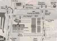
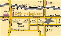
 The Ampang Location Map Cover Area - Jalan Ampang
Kuala Lumpur | Selangor | Johor | Kedah | Kelantan | Pahang | Perak | Terengganu | Negeri Sembilan | Perlis | Melaka | Pulau Pinang | Putrajaya | Sabah | Sarawak | Labuan

| Main > Kuala Lumpur > Jalan Ampang | |||
History Of Ampang Kuala Lumpur's rise from nothing to a bustling town began with 87 Chinese men in search of tin. By fate, these men made their way up the murky Klang River and landed at the meeting point of the Klang and Gombak rivers. However, they only found fortune a few miles east, in a place which is now known as Ampang. At the time, America and the British Empire, needed the durable, lightweight metal to help fuel their industrial revolutions. The community flourished as a tin-collecting center. The tin prospectors flowed into this place they named the "muddy confluence" (Kuala Lumpur in Malay) and settled in Ampang (now a suburb), forming factions within themselves which wrestled for this precious material. Chaos ensued and in 1868, the headmen of the local clans elected a man named Yap ah Loy as "Kapitan China," or leader of the Chinese community. When mining thrived in Ampang, merchants who brought supplies up the Klang River could only get as far as the muddy confluence. So, naturally a town developed at the spot, and he became known as the founding father of Kuala Lumpur. |
|||
| LRT Station Jelatek, Putra LRT Highway Elevated Highway Road Street Jalan Ritchiem, Jalan Ampang, Jalan U Thant, Other Map Link Wangsa Maju, Kuala Lumpur City Centre, Jalan Tun Razak Office Gleneagles Medical Centre, Tara Condominium, Raintree Club, Menara Perkeson, Sucasa Shopping Mall / Complex / Plaza Ampang Park, City Square, Ampang Plaza, Ampwalk Embassy Russia Embassy, Chinese Embassy , British High Commission, U.S. Embassy |
| ||
 Ampang Map |
Street/ Road Ulu Klang, De Palma, Jalan Dagang, Highway Kesas Highway Shopping Mall Ampang Point, Resident Area Taman Dato' Ahmad Razali, IPPD Ampang Jaya, Taman Dagang, Taman Cahaya, Taman Nirwana, Kampung Pandan Dalam, Galaxy Ampang |
||
|
|||
 Jalan Ampang location map