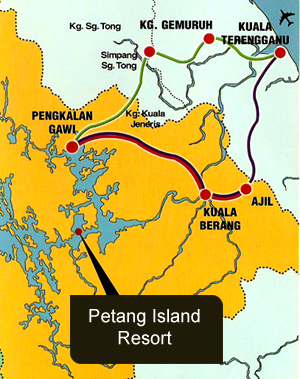
 Petang Island Resort Location Map
|
|
| Home > Malaysia Places > Terengganu > Places of interest > Tasik Kenyir > Petang Island Resort map | |
|
Dubbed as the largest man-made lake in South East Asia, Tasik Kenyir is the pride of Terengganu. With around 340 islands sprawled over 260,000 hectares, this great lake is the result of the construction of the Sultan Mahmud Hydro Dam, Kenyir. The ambience here at Tasik Kenyir is nothing less than captivating. With countless activities centred around and within the lake, river and the surrounding jungle like fishing, water rafting, jungle trekking plus the chance to witness wildlife in their natural habitat, visitors will definitely be craving for more. Whether it is tranquillity and serenity or a heart wrenching, adrenalin-pumping experience you are vying for, Petang Island Resort, Tasik Kenyir has it all.
Our Tasik Kenyir express bus, leaves Putra Bus Terminal Kuala Lumpur for Pengkalan Gawi, Tasik Kenyir everyday.
Getting to Kenyir: Journey on land Our Tasik Kenyir express bus, leaves Putra Bus Terminal Kuala Lumpur for Pengkalan Gawi, Tasik Kenyir at : Morning - 9.45 AM (Thursday - Friday) Evening - 9.00 PM (Every night) Journey by boat from Gawi Point to Petang Island Resort will take you 30 - 45 minutes.
|
Information Search here

Custom Search
rightbottom |
Power By Entertop.net