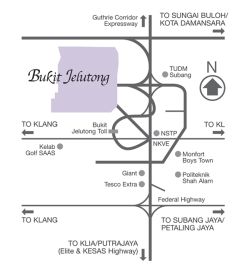
 Bukit Jelutong Map
|
|
| Home > Selangor Map > Shah Alam Map > Bukit Jelutong Map | |
|
Bukit Jelutong, an award winning property development is spread over 2,200 acres of prime freehold land and is a low-density and (with only 4 units per acre) self-contained planned community. Launched in 1995, Bukit Jelutong is a sanctuary in its own world and a prestigious address in one of Shah Alam’s affluent neighbourhoods, every Bukit Jelutong home is elegantly designed and built far beyond the expectations of every discerning homebuyer. Bukit Jelutong Bukit Jelutong is flanked by the prestigious Kelab Golf Sultan Abdul Aziz Shah to the south, the Bukit Cahaya Seri Alam Agricultural Park to the west. It is also well connected to major highways such as North Klang Valley Expressway (NKVE), North South Expressway Central Link (ELITE) and the Guthrie Corridor Expressway (GCE). Bukit Jelutong Bukit Jelutong received the ‘Best Town Planning Scheme Award’ by the Malaysian Institute of Planners, Malaysia in 1997 and the the ‘Best Neighbourhood Landscape in Selangor’ awarded by the Selangor state government in 2001. 
Bukit Jelutong map Highway: Guthrie Corridor Expressway, NKVE, Federal Highway TUDM Subang, NSTP, Kelab Golf SAAS club, Monfort Boys Town, Politeknik Shah Alam To: Sungai Buloh/ Kota Damansara, Klang, Subang Jaya, Petaling Jaya, KLIA, Putrajaya, Elite, KESAS Highway More Bukit Jelutong map 1 and Bukit Jelutong map 1 |
Information Search here
rightmenu

Custom Search
rightbottom |
Power By Entertop.net
