Malaxi.com  Petaling Jaya map - PJ map - Petaling Jaya location maps - pj city map

Kuala Lumpur | Selangor | Johor | Kedah | Kelantan | Pahang | Perak | Terengganu | Negeri Sembilan | Perlis | Melaka | Pulau Pinang | Putrajaya | Sabah | Sarawak | Labuan

Main > Selangor map > Petaling Jaya map
Petaling Jaya (PJ). Just 11 km southwest from downtown KL. Originally a mining area, PJ has been transformed into a modern town of universities, hospitals and businesses. This is Kuala Lumpur's fully integrated development with the Sunway Lagoon at the heart of it all.
More info at Cool spots
logon Understang Petaling Jaya Overview

Pj Section 13 Map
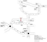
Section 13 Location map

Map provide by Poh Chong Howe
Hotel map:
Hilton Hotel Map, Crystal Crown Hotel Map, Armada Hotel Map

Shoppoing Mall map:

Ampcop Mall Map, JAYA Suppermarket

Highway map:

Federal Highway map.

University map:

University of Malaya.

Office map:
Ducthlady map, Sin Chew Jit Poh map, Philips map.
Pj Section 4 Map
Section 4c Location map
Highway
Federal Highway map, LDP Highway map

Street / Road
Jalan Bahagia map, Jalan SS4B map, Jalan SS4C map

LRT Station
Taman Bahagia LRT Station map, Kelana Jaya LRT Station map

Area
to Damansara map

Office
Motorola office map, Western Digital map, Wisam FAM map,

Dataran Hamodal

Hotel: Armada Hotel, Crystal Crown Hotel, Hotel Lisa De inn, PJ Hiltion

From Phieo Damansara, Jalan Universiti
Rothmans, Sin Chew Jit Poh

From Universiti Hospital/EPF
Handi Mart , Mosque Jalan Semangat Cplgate Palmolive Dataran Hamodal F&N Dairy,Federal Highway Jaya, Shopping Complex Tan Chong Motors, Jalan Kemajuan

Petaling Jaya Sunwaymas Commercial Center MapPetaling Jaya
Jalan Tandang map
Jalan Templer map
Jalan Semangat map
logon Kelana Jaya map
Paramount Garden Map provide by William How
PJ Section 13 map
Taman Sea map new
Section 17 map
Section 19 map
SS 2 map
UPM Veterinary Clinic Petaling Jaya
More Petaling Jaya map


Home | Contact Us | Map Request | Free Submit Info | Petaling Jaya map