Malaxi.com Negeri Sembilan city road street and highway map collection  

Kuala Lumpur | Selangor | Johor | Kedah | Kelantan | Pahang | Perak | Terengganu | Negeri Sembilan | Perlis | Melaka | Pulau Pinang | Putrajaya | Sabah | Sarawak | Labuan

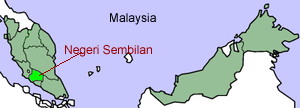
Main > Negeri Sembilan map

Negeri Sembilan (NS) (also Negri Sembilan, Jawi: نڬري سمبيلن), meaning "nine states" in Malay, is a state of Malaysia. It is located on the western coast of Peninsular Malaysia, just south of Kuala Lumpur and is bordered in the north by Selangor, in the east by Pahang and in the south by Malacca and Johor.

The name is believed to derive from the nine districts or nagari (now known as luak) settled by the Minangkabau, a people originally from West Sumatra (present-day Indonesia). Minangkabau features are still visible today in traditional architecture and the dialect of Malay spoken. Unlike the hereditary monarchs of the other royal Malay states, the ruler of Negeri Sembilan - known as Yang di-Pertuan Besar - is selected by the council of undangs who lead the four biggest districts of Sungai Ujong, Jelebu, Johol, and Rembau.

The capital of Negeri Sembilan is Seremban. The royal capital is Seri Menanti in Kuala Pilah district. Other important cities are Port Dickson and Nilai.

The Arabic honorific of the state is Darul Khusus ("the Special Abode").

The ethnic composition in 1995 was: Malay (391,500 or 46%), Chinese (220,000 or 36%), Indian (123,200), Other (10,800), Other Bumiputra (7,000). For political purposes, the Minangkabau residents of Malaysia are regarded as Malay.

Negeri Sembilan map

Negeri Sembilan Map
Senawang map
Seremban map

Nilai map
Port Dickson map
Places of interest
More Negeri Sembilan map here

Download: Negeri Sembilan Map new

Information Search here
Custom Search

negeri sembilan flag
Negeri Sembilan Flag

Coat of Arms
Coat of Arms


rightbottom
Home | Contact Us | Map Request | Submit Info | Negeri Sembilan map collection
Power By Entertop.net